Disclaimer: I’m currently the Chief Evangelist for the photo sharing site Zooomr. We would be seen as a competitor to Flickr and have been developing in the geotagging space for the past six months or so. I’ll try to keep this review as objective as I can.
Ok, so Michael Arrington leaked it a few weeks back and now it’s official. Today Flickr launched geotagging. My first impression? It’s pretty damn impressive.
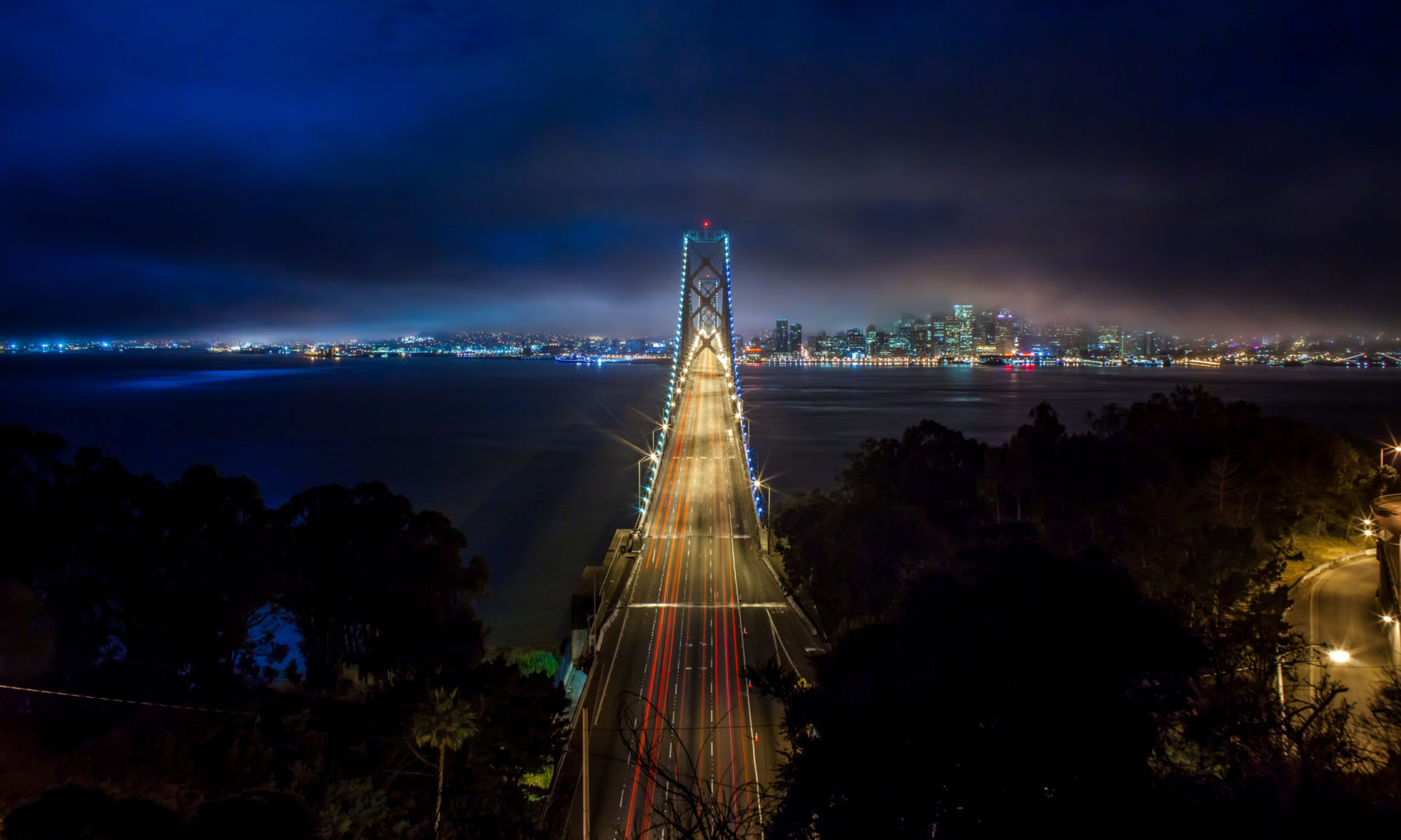
 Flickr Maps, San Francisco Hosted on Zooomr
What makes Flickr’s new geotagging tool so strong in my opinion is that it is tied to their organizer which I’ve always felt is the single best and most impressive part of the Flickr interface. The way it works is pretty simple. You simply find a location using Yahoo! Maps (you can enter an address, airport code, city, etc. or just navigate around the map until you find where you want to go) and then from the organizer’s thumbnail bar below you simply drag and drop your photos on to the map in the appropriate location and you are finished. Like a lot of things at Flickr, simple and elegant.
So what else do I like about Flickr’s new geotagging service? Another great feature that they have added is the ability to screen geotagged locations by text tags on photos. The photo below is an example that I pulled up for all geotagged shots of San Francisco’s favorite eccentric, 12 Galaxy Ambassador Frank Chu.
 Flickr Maps, Search by Tag Hosted on Zooomr
I think it is pretty cool that as more people start geotagging on Flickr that you will be able to have a map of a bunch of places that Frank hangs out around the city. You can use any tag of course and I’d think tags like restaurant, bar, park, etc. over time would all become useful filtering tags to look for photos in a specific area.
Using either tags or all photos you can basically go to any area on a map and browse the location (see below). Flickr clusters photos inside of little pink dots. You just click on the pink dots and then you can cycle through any photos via little thumbnail shots right there on the map.
 Flickr Maps, Explore Photos Nearby, #2 Hosted on Zooomr
The tagging functionality is also helpful when trying to mass geotag your photos. You can for instance pull up a location (say the Golden Gate Bridge) that you might have multiple shots up and then filter by tag “Golden Gate Bridge” and add your tags quickly onto the map.
Another thing that is good that Flickr does is they have a little privacy warning screen when you decide to geotag for the first time. This little screen warns you about the dangers of geotagging and is a good check and balance to make sure that people are aware that geotagging your house, for instance, may or may not be something that you wish to do. Certainly lots of public areas are probably pretty harmless to geotag, but people should in fact be aware that by making their geotags public they let people know where they were at a specific time as well as places they might frequently be at. My own advice to anyone geotagging is to feel free to geotag most of your shots but be careful about geotagging things like your home.
Flickr has all three of the different Yahoo! map views available, regular maps, satellite maps (see below) and hybrid maps which overlay satellite images with street names.
 Flickr Map, Tagging in San Francisco Hosted on Zooomr
So what don’t I like about Flickr’s new geotagging? A few things — and I’d assume that they get these fixed as they continue to develop it.
First off I think that Yahoo! Maps itself has some limitations. Yahoo Maps is especially weak in terms of street detail in Europe and so if you live in Europe you might be less than thrilled at the level of detail that you can get. Sergey Chernyshev has a great little tool that allows you to compare locations on maps using both Google and Yahoo maps side by side. If you put in Paris, France, for instance, you will see that the Yahoo! maps comes up without data at the street level. You can of course zoom out but this will make it harder to precisely geotag for many people living in Europe. I suspect that it’s only a matter of time though until Yahoo Maps gets better coverage and this is improved.
The other thing that I don’t like is that when you add a photo to the map in organizer that it still leaves the thumbnail in your photos. As you add photos to the maps on Flickr you should only want to add photos that have not already been geotagged. The organizer doesn’t have a good way to filter out only non geotagged photos (that I could tell) and so I found myself re-geotagging photos that I’d already geotagged.
The other thing that I didn’t like was that in order to browse and view photos that had been geotagged on a map you have to do it with tiny little thumbnails inside of the map. You can expand an individual photo but then you go to that photo and are off the map. I found it hard to see the detail on such small thumbnails and wished that there were a page with slightly bigger photos where I could click to see nearby photos a tad larger and in more detail but still grouped together.
Of course all of this business with geotagging (and not just at Flickr) raises a serious point that must be considered as well. In the past I’ve been critical of the fact that I’ve felt that my text tags have been locked into Flickr. This is not by Flickr design of course, they just have different priorities right now over building tag export tools etc. But the fact remains that I cannot get my tags out of Flickr and have them exported to another application. My frustration in the past has been due to the fact that I’ve spent hours and hours of time tagging photos and have not had an easy path to get this metadata out of Flickr. Geotagging of course is an even larger investment in time. With over 6,000 photos on Flickr now I’d probably want some pretty serious guarantee that my text and geotags would in fact be portable at some point before investing the amount of time necessary to commit to geotagging at Flickr.
In fairness, even at Zooomr we don’t have these types of export tools yet (we too have been working
on other things ahead of these tools as well). But both Zooomr and Flickr and any other photo sharing site that is entrusted as a steward with user’s content ought to be committed to figuring out the portability issue and at least committing to their users that export options will be available at some point in the future.
I’m sure Flickr will be working out a bug here and there in the next few days and weeks, but this first effort into geotagging is damn impressive. Most of all I find the simplicity and the usability to be it’s strongest features, combined with the advanced filtering tools available through both geo tagging and searching for geo tags based on text tags.
Congratulations to Stewart and the whole Flickr team on this great new feature for Flickr and their users. You can click here for the official take from the Flickr Blog. There is also a thread over at Flickr Central on the matter as well. (I am of course a tad bitter that I was the first person to post on this at Central only to have my post deleted with zero correspondance from a Flickr Central admin as usual) Paul Stamatiou has more here. Robert Scoble chimes in here.
Update: Scott Regan from the Yahoo! Maps team responds about the coverage of street detail on Europe maps: “We hear you loud and clear on street level detail for Europe and beyond. We�ve been working hard to rollout more international data and imagery over the last few months and will keep it coming.
In the meantime, we�re focusing on keeping a good balance of global coverage. If you�re geotagging photos from a recent trip from outside the US, Europe, or Japan, you should find major cities, towns and road networks for every country.”
Update #2: Stewart Butterfield responds to a couple of my items in Flickr Central. There does appear to be a way to filter your photos by non geotagged photos but it does not yet work with the tag filtering. This is a good feature to have but it’s a bit of a pain to try to geotag your photos by chronological upload vs. by tag refinement for all specific photos by event, location, etc. (eg. “Tag Cathedral” “Alameda County Fair” “Mountain View Cemetery” etc. There is also a way to view larger versions of the photos still within the flickr map vs. only being able to see the tiny thumbnails.
From Stewart: “For the first issue, you can actually choose the awkwardly-named “All your photos not on a map” (we’ll change this) in the Organizr and then photos will disappear after you geotag them.
For the second, when you’re looking around flickr.com/map, you can click the “Show detail” thing in the top left of a photo window or click on the center photo to browse through those photos at a larger size.
So, that leaves Yahoo! maps overall coverage – I’ll write a little more about that soon 🙂 “
Update #3: Rev Dan Catt (from Flickr) responds to a question about existing exif geotags integrating into Flickr Maps (this can be done, users just need to activate it at the address below first).
Dan also responds to the concern about portability of geotag data by suggesting that users geotag their original photos prior to uploading them to Flickr if they are concerened about having access to this metadata later and a mention of Flickr’s API as another vehicle to get access to this data.
From Dan:
“Flickr can use location information from the EXIF data, you just need to turn it on…
http://www.flickr.com/account/geo/exif
…once switched on, any data in *new* photos uploaded will be used.
So if you’re worried about taking your geo info with you, embed the location first and then upload the photo. We won’t embed it for you as we have a policy against making any modifications to your original files.
As always you’ll be able to get your geo information back out using various APIs.
I like the idea of being able to map your photos. Rather than Geotagging then I am able to Geocode them with a GPS attached to my camera. I have many such photos uploaded to Flickr already. I have noticed that their support for this is lacking. They can clearly parse out the GPS coordinates as can be seen in the EXIF data of such a picture. However Flickr’s new tool does not seem to map any of those pictures with the already supplied information. I would think that support for this feature should be in the works. Reguardless I am still dissapointed that they did not first support the people with the information there, and then look to add support to those willing to put the information there.
Thomas, thanks for the review. I’m glad that you can still write objectively about Flickr and acknowledge similar shortcomings in Zooomr’s service as well.
I’m totally awed by the Flickr-Upcoming integration… ironically I don’t have the same concerns about Yahoo! as I do about Google, but maybe that’s because they haven’t consolidated their logins yet (even though you can share your avatar).
Still, it’ll be interested to see what kind of cross-polination you can come up between Zooomr and Flickr.
This message is for all the Slashbots:
– Linux SUCKS
– OSX SUCKS
– Windows RULES
– MICROSOFT IS MAKING ONE BILLION DOLLARS IN CASH PER MONTH
– RMS IS A SMELLY HIPPY
SO suck it!
to be fair to Flickr, you can pull all your photos tags from their database via their API. see the flickr.photos.getInfo method
Thomas, in Organizr you can choose to select photos “Not on the map.” This updates as you geotag. Granted, it’s not an advanced search, as your photos are then organized by date posted, but it is still quite useful, I found.
Sadly it only works for America right now. The yahoo maps outside (eg for me in Japan) are pretty, or well, at all useless. The Google Maps are already very accurate.
I just wished, Yahoo America would use the maps Yahoo Japan is using. That would be awesome.
Wow! Great review. I randomly happened upon this function today when I was reorganizing a new set of photos. So now the question is how low-level of a geotag do you add? Will you show us the exact location of your battle with the security guards?
Is there a possible to automatically add a tag “geotagged” to all geotagged photos. It seems to me that that’s been standard for now. If that’s the cast maybe you could filter photos within the organizers by not having this tag, and maybe it’ll update automatically.
…k, I see, that’s a stupid message. I should just try it.
Jack
I can’t wait for the content management systems to support this.
it is still awfully slow, and having to reloading the pictures to show pics that are “not on the map”. Euro cities are very lame, having only helicopter view without any streets details. i can’t imagine how an asian city would look like. yahoo maps sucks. but it is an interesting features from flickr. can’t hardly wait for bugfixes..
Anonymous #1
Flickr can use location information from the EXIF data, you just need to turn it on…
http://www.flickr.com/account/geo/exif
…once switched on, any data in *new* photos uploaded will be used.
So if you’re worried about taking your geo info with you, embed the location first and then upload the photo. We won’t embed it for you as we have a policy against making any modifications to your original files.
As always you’ll be able to get your geo information back out using various APIs.
I’m one of the guys behind Panoramio, a community of geotagged photos. Panoramio includes a drag and drop geotagging interface to locate your photos over Google Maps. You also can watch the photos in Google Earth through KML feeds.
Already 38.000 photos have been geotagged in Panoramio. I would like to hear you opini�n about our site.
Regards,
Eduardo
I really wish one could geotag from the photo page as well.
Now all we need is GPS embedded into the camera. The GPS coordinates are embedded into the picture, uploaded to Flicr and we have auto GeoTagging….
Hi
“Now all we need is GPS embedded into the camera. The GPS coordinates are embedded into the picture, uploaded to Flicr and we have auto GeoTagging….”
We made a small app that writes the gps-data into the digital photos, so it would even be more easy to get the pictures geotagged..it works with a lot of gps-receivers..you only have to convert the gps-file to a gpx file using GPS-BABEL ( its for free )
our software is also for free..If you are interested drop me a mail, best regards, Jens
In playing around, I found that not only was the street-level data not as good as Google in Europe and Mexico, but the satellite images were also poor. If you have neither, it’s virtually impossible to match things up well.
to be fair to Flickr, you can pull all your photos tags from their database via their API.
You can get your data out, but matching it up to the right original photo is not fun. Flickr doesn’t have the filename.
Does Zooomr have a future now, or do you have some plans for features that flickr doesn’t have?
Paul, oh yeah, Zooomr has a future. Stay tuned.
Great balanced review and analysis.
Is it just me or do I feel like the child of Web 1.0? Granted, I blog. Granted, I use Flickr. Granted, I use MySpace (with great reluctance on my part). But to me, putting my life on line and where I have been EXACTLY at what TIME for all to see just inspires utter terror from me.
Is this Web 2.0 gone horribly wrong? What is next? Dynamically tracking your movement (via your consent!) using AJAX and your cellphone? Include a DynaTracking widget on your blog?
“I like the idea of being able to map your photos. Rather than Geotagging then I am able to Geocode them with a GPS attached to my camera.”
“Now all we need is GPS embedded into the camera. The GPS coordinates are embedded into the picture, uploaded to Flicr and we have auto GeoTagging….”
Yeah, so obviously we already have camera that can inject GPS data to an images EXIF. Personally, I use my mobile phone to take a photo and easily inject the GPS data, but I understand that mobile phone technology around the world is not all equal.
However, GIS people have been geocoding for quite some time… there are software out there for added GPS data…. or more clumbsy methods of recording GPS data, then inject in later by comparing with the images time stamp.
If you want to be able to integrate geocoded data into your own php website, feel free to use the geocode exif extraction functions here
http://map.derekwallace.com/Sample_GIS_Image_Extraction.php.txt
However, aside from speed, i’m pretty happy working with GoogleMaps to plot photos onto a map… especially as some have mentioned, GoogleMaps in Japan is fairly decent.
And hope to integrate geocoding with a WordPress plugin… but if flickr made a convenient tool for automatically parsing geocode data and being able to put it onto your own website with a geocoded map… then that might convince me to join my colleagues and make the transition to flickr…
“”Is this Web 2.0 gone horribly wrong? What is next? Dynamically tracking your movement (via your consent!) using AJAX and your cellphone?””
We can already track people through GPS in their mobile phones in Japan… for example: a mother wants to know where her kids are or wants to be automatically notified when here kids reach home… japanese mobiles phones can do that….
however, if you search news articles on the topic, being able to use the tracking feature, hasn’t always been able to save lives of thoes kidnapped…
Derek Nobuyuki Wallace
You may be aware that if you have currently got uploaded photos containing GPS data inside the EXIF then this data is not being loaded into Flickr’s new Location database.
The following is a little web app that does just that for you.
http://www.wackylabs.net/dev/georetagr/
It uses phpFlickr and I managed to write it in about 1 day.
Give it a whirl and let me know what you think.
Sam
As for extracting the location/tagging data out of flickr, I’ve been thinking about this these days – I thought what we need is some kind of advanced Uploadr for Flickr that after it uploads an image to Flickr, it would go and retrieve the image id from Flickr and tag the original image file on the users computer with the Flickr image id. Then you can go ahead and tag/getcode your photos on Flickr. Once you’re done (or at any time), the Uploadr/Synchronizr could then go and retrieve the data through the Flickr API and update your local images with the tags/geocoding.
Hahaha, you at Zooomrr are losers!
GPS-CS1 sony GPS tracker and software… boom… done.
I have to agree that the major downside of the Flickr implementation is the lack of information in Yahoo! Maps 🙁
The ease of use is otherwise great.
I must say the user interface wel dome by flickr. I have been strugling with the concept of location and memories for a while now, and lanched a concept http://www.emotionalfootprints.com begining of this year. we use location data from the mobile network and upload of tracks in gpxformat for matching of photo’s and coordinates. al this is plotted on google maps, since the service has an european focus.
Speaking about “geotagging”: do you know locr?
locr offers the ideal solution and makes geotagging exceptionally easy. locr uses GoogleMaps with detailed maps and high-resolution satellite images. To geotag your photos just enter address, let locr search, fine-tune the marker, accept position, and done! If you don�t know the exact address simply use drag&drop; to set the position.
For automatic geotagging you need a datalog GPS receiver in additon to your digital camera. The GPS receiver data and the digital camera data is then automatically linked together by the locr software. All information will be written into the EXIF header.
With locr you can upload photos with GPS information in them without any further settings. In the standard view, locr shows the photo itself, plus the place it was taken. If you want to know more about the place where the photo was taken, just have at look at the Wikipedia articles which are also automatically assigned to the picture.
Have a look at http://www.locr.com.
Great review – I agree that Flickr’s ability to GeoTag visually is pretty amazing. This review is far more comprehensive and fairly objective as far as I can tell 🙂 than most out there.
For anyone interested, these are a few good resources on geotagging the photos (on a PC) before upload to Flickr or to Zoomr, allowing the tagging of RAW files, etc.
It’s good to have some news !thanks!
Really nice information, thanks for sharing?thanks!
I�m not using locr �
I found this site http://www.trekinu.com much easy to share my albums.
Trekinu is very neat and easy to use tools I like the idea and in 5 simple steps you have something to send to your friends or share in your site.
You can check this trek for example: http://www.trekinu.com/viewtrek.aspx?trkid=8h5b5glzsxa1h43
I can’t wait for the content management systems to support this.
ove-weight-two/ _
Thanks! That worked perfectly. I really missed GrowlMail and I’m glad to have it back.
It is not clear
nteresting article. very good!!!
a very interesting position from a scientific point of view
?????????????????
?????
???????
Some of my geotagged photos lost its position when upload to Flickr and for no reason. The same photo can be recongnized by Locr automatically.
I use Easytagger GPS which can geotag automatically, it adds the gps data into the exif when taking the photo and it also can log the trails. A very useful Nikon GPS
If you can hold something up and put it down, it is called weight-lifting; if you can hold something up but can never put it down,it’s called burden-bearing. Pitifully, most of people are bearing heavy burdens when they are in love. ?
Flickr keeps going from strength to strength. This is an excellent addition
Hm, Now i am ok with this nevertheless not fully convinced, therefore i am gonna research even more.